Patnitop (J&K) to Shivgarh Ridge Trek
Have an urge to expend some pent-up energy or perhaps challenge yourself of a difficult trek around Patnitop? If yes, then look no further than this trek along Shivgarh ridge overlooking Patnitop. This ridge connects Patnitop woods with a meadow that lies on the Patnitop-Gaurikund trek route.
Table Of Contents
Trek Diary
It is believed the Gaurikund is the legendary spring where the Goddess Parvati used to bathe before commencing her daily prayers at Sudh Mahadev. A temple that was constructed at this spring came to be named after her as ‘Gauri Kund’ (Gaurikund) - Kashmir Tourism
This route takes you through forests, over boulders, around a meadow and finally down a steep mountainside. It starts and ends at Patnitop and makes a satisfying day trek. It is satisfying because you will be traversing an uncharted route. The countryside is yours and yours alone and you will seldom come across another trekker on this route. There are other easier routes that link Patnitop with Gaurikund. However, easier is not always better or as satisfying.
Trek Detail
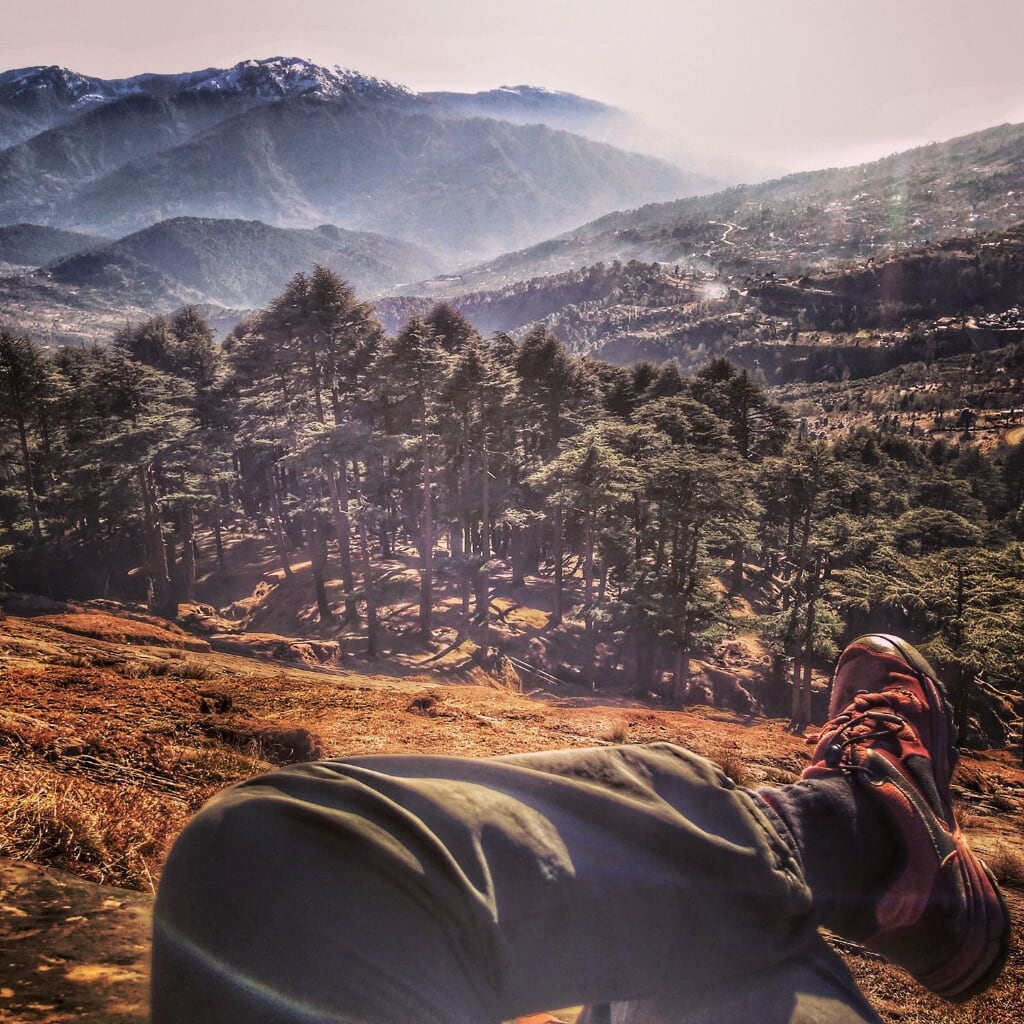
The trek starts near Hotel Green Top in Pattnitop. Follow the walking trail next to the hotel gate, that leads to a water pumping station. From the water pumping station, follow a couple of water pipes along a well-defined forest trail. Water refill points and small streams abound along this narrow forest trail. Refill your bottles at one of these water points because there is no potable water for the next five kilometres. You break through the forest at a grassy knoll that is around 2.3 kilometres from the starting point. The grassy knoll overlooks the forest and provides a beautiful unencumbered view of Shivgarh ridge.
From this knoll, you begin to appreciate the ridgeline that you will be traversing. The ridge undulates like a wave, meandering its way to a treeless meadow. The ridgeline, for the most part, is a narrow rocky ledge straddled with rocks and covered with trees on both sides. In most places, you will be scrambling through or over these rocks, sometimes on all fours for a better grip. The drop on both sides is steep. A mantle of slippery rotting pine needles covers the steep side slope and this route is best avoided. The narrow ridge widens into a grass-covered saddle at two places. These saddles, ringed with trees on all sides are an excellent place to pitch a tent. After about two kilometres from the knoll, the ridge finally opens up to a gently sloped meadow. After all the scrambling and exertion, walking along a gently sloped, wide grassy meadow is a good way to unwind. This meadow is a great place for lunch or a snack. There are endless meadows interspersed with dense deodar and fir forests to the South and the East. In the monsoon, clouds shroud these meadows in a mysterious aura.
Continue south-east along the well-marked path just below the meadow. A kilometre along this trail brings you to a scree-covered gully with a steep descent. A Gujjar family that I met on this trail assured me there was no way down this steep gully. However, if you are careful, it is possible to make this descent. Trekking poles will give you two extra points of contact and they are extremely useful on this descent. Just make sure to extend your trekking poles a bit before starting the descent. Zig zag your way across scree and rocks down the mountainside. Once the descent is completed and the adrenaline rush fizzles off, find the well-defined trail due east. The trail twists through a dense forest back on to Patnitop. This forest trail is dotted with watering points along the way.
Zigzag your way across scree and rocks down the mountainside. Once the descent is completed and the adrenaline rush fizzles off, find the well-defined trail due east. The trail twists through a dense forest back on to Patnitop. This forest trail is dotted with watering points along the way.
Trek Summary
- Type - Day Trek. Difficult.
- Difficulty - Swiss Alpine Club (SAC) Scale - T3.
- Trek Duration - 5 to 6 hours.
- Trek Distance - 10.6 kilometres.
- Start & Finish Point - Trek starts at Hotel Green Top, Patnitop and ends at Sudhmahadev sanctuary road, Patnitop.
- How to reach Patnitop - Bus / Taxi. Patnitop is well connected by bus with Jammu, Udhampur, Ramban and Srinagar. Taxi can be hired from Patnitop.
- Hotels and Stay - Hotels for every budget are available at Patnitop. There is a youth hostel at Patnitop.
- Weather - Pleasantly cold during the day, late evenings can get very cold and cloudy, often reducing visibility.
- Summary - Involves a difficult ascent and a steep descent over an unmarked trail.
- Caution – This is not a trek for beginners, make sure you have some trekking experience before attempting this route. The chief danger is that of a slip, so watch your step especially during monsoons. When it rains, the ridge and the meadow are often obscured by clouds which reduces visibility to a couple of metres.
Essential Gear
- Trekking Poles – recommended for the descent, they give two extra points of contact over rough ground.
- Gaiters – keep shoes pebble and scree free.
- Lightweight windproof jacket – It can get windy along the ridge, the jacket comes in handy when you are cooling down or taking a breather.