Chattargala pass to Sonbain Glacier trek
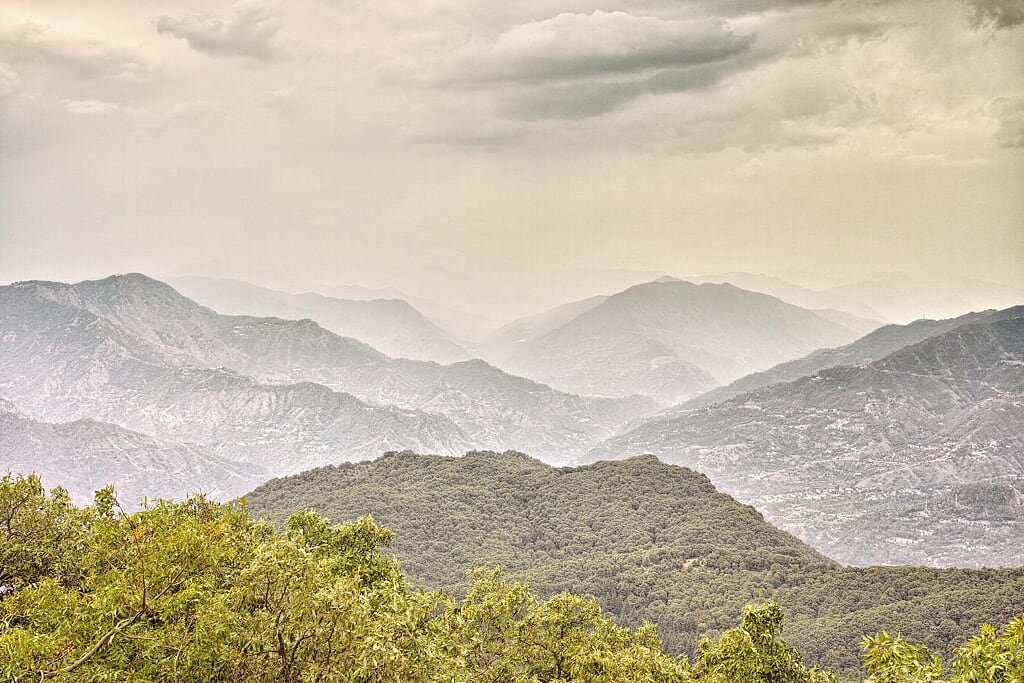
Sonbain (elevation 3130 metres) is a glacier near Bhaderwah (Jammu & Kashmir). Whereas the approach to most glaciers is usually devoid of any vegetation; Sonbain glacier is a bit of an anomaly. The slope below the glacier is a natural flowerbed.
Table Of Contents
Trek Diary
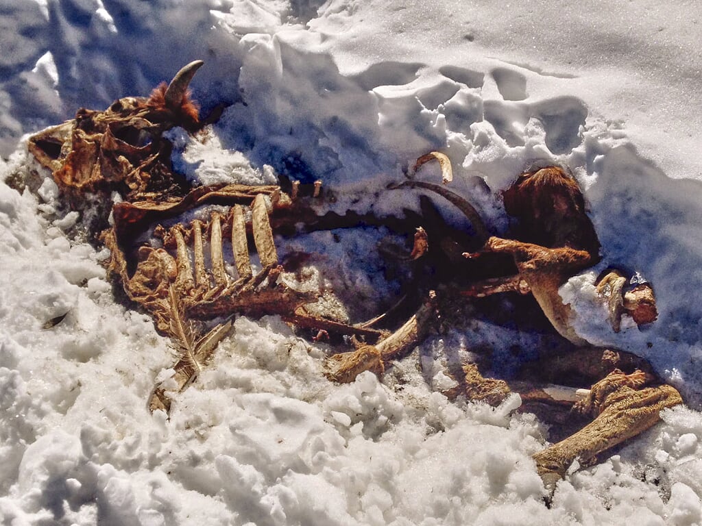
After the monsoons, this slope erupts in a riot of purple, yellow and red colour flowers that makes Sonbain a vibrant and cheerful glacier to visit. A mountain stream emerges from the glacier gurgling with ice cold water. This stream later joins other mountain streams to form Neru river in Bhaderwah. Flanked by a dense coniferous wood on one side and a shrub covered alpine mountain on the other, Sonbain is melting pot of coniferous and alpine ecosystems. This unique ecosystem makes the area around Sonbain a fauna watcher’s paradise. If you are patient, you may just glimpse a white-bellied Himalayan musk deer (Moschus leucogaster) or an Asian black bear (Ursus thibetanus) near the ridge overlooking the glacier.
Trek Detail
The usual route to Sonbain glacier starts from Guldanda/Padri Gali on the Bhaderwah – Chamba road. However, for this trek I wanted to explore a different route and since I cannot find any reference about this route online (or from Gujjars) I reckon this is the first attempt that connects Sonbain with Chattargala pass. The trek starts and ends at the road head on the Bhaderwah-Sarthal-Bani-Basholi road, just before Chattargala pass. Sonbain glacier is visible to your left as the road winds its way from Bhaderwah to Chattargala. Trek along the ridge overlooking the glacier and then descend a very steep slope through a wooded section.
The starting point is a mountain stream on the road head. Trek uphill along the mountain stream towards the ridge top. The first 500 metres along the stream are steep and slippery. Wet and moss covered rocks are best avoided. A faint trail is visible off and on at certain places along this stream, and it is your best guide over some tricky slippery sections. After this first half kilometre of sheer climbing, the route eases off as you leave the stream to your right and follow a grass covered meadow to the ridge top. This meadow is criss crossed with shepherd trails used during the cattle grazing season stretches from June to October. Meet the ridge at a conspicuous col. From this col, climb this bald ridge line in a North-Westerly direction. In every direction, the views from this ridge are mesmerising. Especially beautiful is the view over Sarthal meadow. The meadow lies cradled in the gentle arms of majestic mountains. A well defined shepherd trail follows the ridge if you keep Bhaderwah to your left. I spotted a musk deer along this ridge, however it was extremely wary and bolted before I could reach for our cameras. I was later warned by shepherds that this ridge is also frequented by black bears foraging for food, and thus it is best avoided late in the evenings.
This meandering trail just below the ridge leads to a hillside scattered with boulders and an abandoned shepherd camp that overlooks the glacier. Be extremely careful when descending through this boulder field and then on through a dense wood. The descent through the woods is more treacherous as the trees and vines frequently obscure steep rock faces. Emerge from this wood at a field of flowers at the base of the glacier. The return route is shorter and without any significant ascends. However, it is more treacherous as it requires crossing two mountain streams along a sheer mountain face. This is not a route for the faint hearted. Descend from the glacier due east, till you come across the first mountain stream. Head downhill along the stream to a thicket of trees and shrubs. Cross along this short shrub covered section. Branches and scrubs provide grab points as you criss-cross precariously along a sheer mountain face. Ensure you have two stable anchor points before taking the next step forward. The second stream is to be crossed in the same way, grabbing on to shrubs and stunted fir trees for support. After the second stream, climb through the dense woods to a plateau with a shepherd camp. After this plateau it is a fairly flat walk over a few knolls to the road head and on to the only tea stop on the Bhaderwah-Bani road.
Trek Summary
- Type - Day Trek. Difficult.
- Difficulty - Swiss Alpine Club (SAC) Scale - T5.
- Trekking Duration - 6 to 8 hours.
- Trekking Distance - 4.3 kilometres to the glacier and 3.6 kilometres return.
- Maximum Elevation - 3576 metres.
- Starting Point - 1.5 kilometres after the tea shop before Chattargalla pass
- Finishing Point - The tea shop before Chattragalla pass
- How to reach Bhaderwah and Chattargala - Bus / Taxi. Bhaderwah is well connected by bus to Jammu, Udhampur, Ramban and Srinagar. Taxi can be hired from Bhaderwah for Sarthal and on to Bani. There are 3 mini busses that ply everyday on the Bhaderwah-Bani route. Average time by bus from Bhaderwah to Chattargala pass is 2 to 2.5 hours one way
- Hotels and Stay - Hotels for every budget are available at Bhaderwah bus stand. No accommodation at Chattargala. There is a cheap hotel at Sarthal.
- Terrain - Involves a steep ascent and a difficult descent over an unmarked trail. A tricky thickly wooded section and crossing two mountain streams across a sheer mountainside.
- Weather - Cold during the day and sub zero at night. A thick cloud cover may reduce visibility along the ridge and the glacier.
- Caution – This is a trek for experienced trekkers. It involves a dangerous descent and high altitudes. Ensure that you have adequate high altitude trekking experience before attempting this route. After noon, the ridge and the glacier are often enveloped in clouds which may reduce visibility drastically.
Essential Gear
- Trekking Poles – recommended for initial ascent along the mountain stream. Not recommended for descent as you will need your hands free to grab trees and scrubs.
- Binoculars – For fauna gazing
- Fleece inner and windproof jacket- It is usually cold and windy along the ridge.
- Sunscreen and sunglasses with category 4 lenses – This is a high altitude trek and the chances of getting a sunburn are high on a sunny day. If you plan to walk along the glacier, category 4 lenses will help reduce chances of eye strain or possible snow blindness.