Ambivali to Peth Kothaligad fort monsoon trek
Kothaligad is a small funnel fort near Karjat (Maharashtra). The fort is also called “Peth Fort” because of its vicinity to Peth village. Unlike other funnel hill forts, the pinnacle or the funnel is carved from the inside, forming a circular staircase that reaches the top. The superlative view from the top of the pinnacle combined with this unique and awe-inspiring engineering feat deserves a visit.
Kothaligad is accessible via a moderate 5.6 kilometre/3 hour trek starting from the road head at Ambivali village. A dirt road connects Peth village to Ambivali and this makes Peth village accessible with a motorcycle or a four-wheel-drive vehicle. However, I recommend walking to Kothaligad because there are some stellar view points along the way.
Table Of Contents
Trek Diary
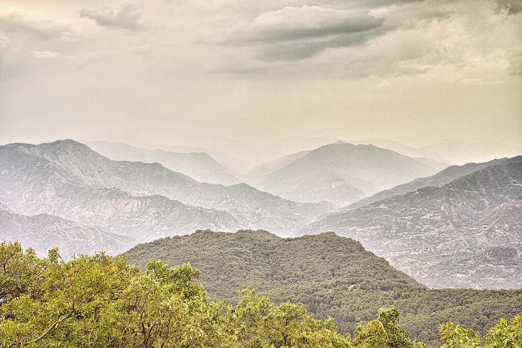
Peth is a small plateau, with a prominent funnel-like pinnacle on the top. The pinnacle called Kothaligad, is a watchtower or a fort, depending on your interpretation. Because of its strategic elevation and location, the fort has passed many times between Maratha and British hands. Till 1862, the British held this fort as an outpost for vigilance. As with most Sahyadri treks, the best time to visit Kothaligad is during the monsoons. The interplay of clouds and waterfalls along the plateau walls is the best in this season. During the monsoons, the pinnacle is usually draped in clouds and you might have to wait for gaps in the cloud cover, to be able to peek at the countryside. An early start gives a better chance of viewing and photographing the surrounding countryside.
The drive from Nerul to Ambivali via Kashele is sublime. There is hardly any traffic and the road passes through some sleepy hamlets and eye-catching rural landscape. Ambivali is a large village with a number of shops and restaurants. On reaching Ambivali, we were surprised to find that a dirt road connects Ambivali to Peth village. This road is accessible by a motorcycle or by using a four-wheel-drive vehicle. This meant that we could take our Maruti Gypsy to Peth village if we wanted to. Yet, we decided to complete this stretch on foot because a) a walk is a better way to explore the surroundings and b) it makes the trek report more relevant for people who plan on taking public transport till Ambivali village. With this in mind we parked the Gypsy in an open space at the Peth – Ambivali bifurcation. Walking up the motor-able Peth road is a doddle and there is a small step waterfall along the route that should not be missed (see Trek Details and GPS logs).
Peth is a prosperous farming village with running water and electricity and extremely likeable, friendly villagers. We reached the village in a heavy monsoon shower. As we stood huddled under a villager’s hut waiting for the rain to ease up; the house owner promptly handed us a towel to dry off and asked us to keep the towel as we would need it on our trek to dry off. It is these small gestures of generosity, often made by the poorest people, that help redeem our faith in civilisation. Rural India still has a heart and that heart is huge.
The climb from Peth village to Kothaligad fort is steep yet beautiful. The trail ascends along the North–South axis of the plateau and this route provides a bird’s eye view over Bhimashankar plateau and rock walls. With every metre ascended the view keeps getting better and better. There are a series of caves and a rainwater cistern at the base of the fort. The first cave is small and it has been transformed into a temple dedicated to the fort deity. The next cave is surprisingly large and well-crafted. Carved in solid rock with a series of windows cut out for light, this cave has a level floor and can accommodate 30 people. This is a perfect camping place if you do not mind the occasional screeching bat or mouse critter. The stone pillars and door sills in this cave are carefully carved yet poorly maintained. This large cave leads on to two other smaller caves. These small caves are windowless and thus they are damp and dark. The pungent smell of bat shit and rat droppings gets more nauseous as we dwell into these smaller caves.
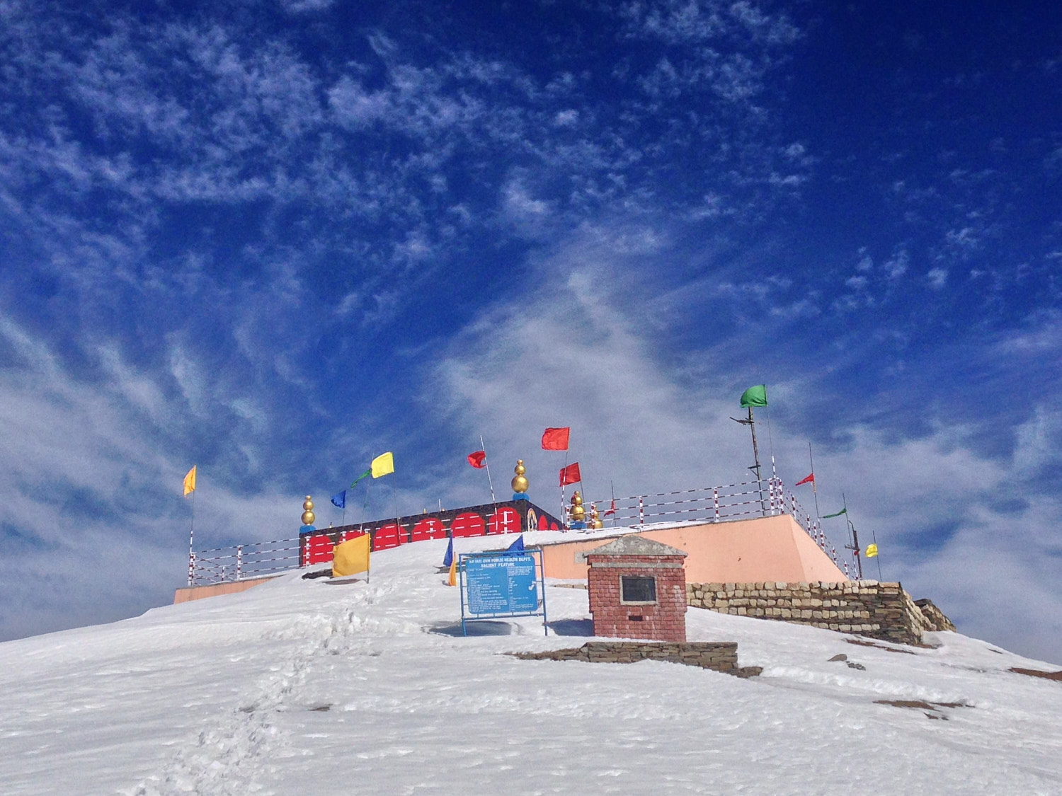
Just before the temple cave is a series of steps carved in stone that lead up inside the funnel. A total of 87 complete and partially broken steps hug the funnel and lead to the top of the funnel. The steps have weathered in a few places, yet the engineering involved in creating this manmade marvel is admirable. A rather large water cistern and a few trees dominate the small plateau top. However, the view from the top of the plateau is nothing less than extraordinary. Kothaligad is detached from the main range and the pinnacle provides a panoramic view over the surrounding area.
A group of village dogs accosted us on our way back to Peth village. These dogs were only too happy to escort us back to our parked Gypsy. Before leaving Ambivali we recommend trying the Poha at Hotel Kothaligad. Hotel Kothaligad is a small family-run establishment and the lady of the house makes and serves excellent Poha topped with fresh tomatoes, chillies and grated coconut.
Trek Detail
The trekking route to Peth or Kothaligad fort starts at Ambivali village. At Ambivali village, near hotel Kothaligad, a road bifurcates from the main Ambivali – Jamrukh road and leads on to Peth. This road to Peth starts as a metalled road and then deteriorates to a dirt road after 700 metres. Take a left on the first Y junction and you are on your way to Peth village. The gradient of the trail steepens after the dirt road starts. Climbing the first kilometre along the dirt road is dreary as there are no views in either direction. 1.7 kilometres from the starting point, a narrow trail breaks to the left of the dirt road and this leads to a gurgling stream washing over a small set of rapids. This spot next to a stream is an excellent place for a picnic, a quick bath or for a short rest.
2.5 kilometres from the starting point the road emerges to the edge of the plateau and at this point, you get a stunning view of Peth village topped by Kothaligad fort. The gradient tapers off after the viewpoint and it is a gentle two-kilometre ascend along the plateau to Peth village.
The real climb starts once you leave the village behind. The trail narrows substantially and the terrain turns wild and rocky. Shrubs and trees press in the trail from all directions. Still, these trees are a blessing if you go trekking on a sunny day as their shade is most welcome. A trickle of water covers most this trail during the monsoons and this makes the rocks slippery and treacherous, especially while descending. Peth village draws its water supply from the fort and a steel water pipe links village to a cistern near the fort. The 1.5-kilometre trail from the village to the fort meanders around this water pipe. The trail zigzags up over loose rocks and scree. In a couple of places there are footholds carved in larger rocks. Be careful on these large rock sections as they tend to be more treacherous. In such places, you may use the steel water pipe as a handrail for ascent or descent. Just before the cave at the fort base the trail gradient tapers off and that is a sign that you have reached your destination.
From the base cave, a series of steps carved inside the funnel lead on to the top of the pinnacle. There is a small section along the side of the funnel where a few steps have weathered and broken down. It requires a bit of scrambling using your hands to get through. A small slit in the funnel next to the weathered steps gives a magnificent birds-eye view over Peth village. Follow these 87 steps to the pinnacle. A large carved rock water cistern dominates the plateau. The water in this cistern is non-potable unless you use a portable water filter like a [lifestraw (my review)]({% post_url 2015-04-18-Water-Filter-For-Hiking-Lifestraw-Review %}).
Trek Summary
- Type - Day Trek. Easy to moderate (monsoon).
- Difficulty - Swiss Alpine Club (SAC) Scale - T2.
- Trek Duration - 3-4 hours ascent and 2-3 hours descent from Ambivali village.
- Trek Distance - 5.6 kilometres one way from Ambivali village
- Maximum Elevation - 630 metres / 2,066 feet to the fort base
- Start and Finish - Ambivali village on the Kashele – Jamrukh road.
- Getting To Kothaligad - The best way to reach Kothaligad is to take a suburban train going to Karjat and alight at Neral station. From Neral regular shared 6-seater (Vikram / Tum-tum) auto-rickshaw service is available to Kashele. The price is around Rs. 35 per seat. After alighting at Kashele you can immediately board another shared rickshaw going to Jamrukh and alight at Ambivali village. This costs about Rs 25 per seat. These rickshaws are easily available in both direction up to 6pm. Alternatively, one may also reach Karjat station and take a State Transport (ST) Bus going to Jamrukh and alight at Ambivali. However, the frequency of ST buses is low and therefore going via Neral is recommended. The last ST bus from Ambivali to Karjat via leaves at 5:30 PM. From Pune: You can reach Karjat by a morning train. Sinhgad Express which boards, from Pune station, at 6 AM reaches Karjat at 8:15 AM. From Karjat a State Transport bus leaves for Ambivali at 8:30 AM. While returning you may take the ST bus from Ambivali at 5:30 PM, which will leave you at Karjat by 6:30 PM. From Karjat you will get Deccan Queen express at 6:45 PM which is quick and arrives at Pune at 8:15pm. If you miss Deccan Queen express then another next train is Sahyadri express that departs at 7:45 PM which will arrive at Pune at 10:00 PM. Train charges are Rs 40 from Pune to Karjat. And state transport bus charges are Rs 30 from Karjat to Ambivali.
- Hotels and Stay - Neral and Karjat have budget lodges for overnight stay. There is no lodge available in Ambivali or in Kashele
- Caution – During monsoons, the stretch between Peth village and Kothaligad fort is water-covered and slippery. The steps carved inside the funnel may also be treacherous if wet. Exercise caution at both these places especially when descending.
Essential Gear
- Poncho / waterproof clothing for rain protection.
- Trekking poles for the ascent till Peth Village.
- Trekking shoes with deep lugs for wading through mud and over wet rocks.
- One litre of water per person or a water filter system like a Lifestraw.
Downloads and GPS logs
Related
- Ambivali to Peth Kothaligad fort trek route as an interactive map
- [Karnala Fort and bird sanctuary]({% post_url 2015-07-18-Karnala-Fort-And-Bird-Sanctuary-Monsoon-Trek %}).
- Bhimashankar.
- [Irshalgad pinnacle monsoon trek]({% post_url 2015-07-29-Irshalgad-Pinnacle-Monsoon-Trek %}).